

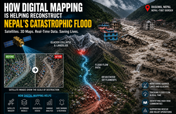

The devastating floods that struck the Nepal-Tibet border region have left behind destroyed settlements, damaged roads, buried infrastructure and dramatically altered river valleys. While rescue teams continue working on the ground, researchers are turning to an increasingly important set of tools to understand how the disaster unfolded: satellite imagery, digital mapping and 3D visualisation.
Change block type or style
Move Paragraph block from position 2 up to position 1
Move Paragraph block from position 2 down to position 3
Change block type or style
Move Paragraph block from position 2 up to position 1
Move Paragraph block from position 2 down to position 3
Change alignment
Change text alignment
Displays more block tools
blob:https://theprimebrief.com/a8a0a5ed-d362-4885-9035-e41d71e34e54Meta Boxes
Use up and down arrow keys to resize the meta box pane.
Change alignment
Change text alignment
Displays more block tools
blob:https://theprimebrief.com/a8a0a5ed-d362-4885-9035-e41d71e34e54Meta Boxes
Use up and down arrow keys to resize the meta box pane.
These technologies are allowing experts to reconstruct the flood from its high-altitude Himalayan origins to the communities and infrastructure damaged farther downstream. By combining satellite photographs, terrain models, geolocated videos and digital archives, researchers can examine a disaster across an entire landscape instead of relying only on what can be seen from the ground.
Reconstructing the Disaster in 3D
Among the efforts highlighted following the disaster is work associated with Professor Hidenori Watanave of the University of Tokyo, an expert in information design, digital archives and visualisation.
The transcript describing the disaster says Watanave created a three-dimensional reconstruction showing how the destructive event developed in the mountains near the Nepal-Tibet border and moved downstream toward populated areas. A 3D reconstruction is particularly useful in the Himalayas because elevation is central to understanding what happened.
On a conventional map, a glacier, river and town might appear to be only a few kilometres apart. A three-dimensional model can reveal the enormous differences in height, the steepness of surrounding slopes and the narrow valleys through which water and debris can rapidly accelerate. That perspective can help explain how an event occurring high in the mountains can devastate communities many kilometres downstream.
Satellite Images Create a Before-and-After Record
Satellite imagery is one of the most valuable tools available after a large natural disaster. Images captured before the flood provide a record of roads, buildings, bridges, river channels, vegetation and other features. New images captured after the disaster can then be compared with the earlier landscape.
The differences can be dramatic.
Buildings may disappear completely. Roads can be covered by debris. Rivers may widen or change course. Bridges can be washed away and previously populated areas can become fields of mud, rock and sediment. This type of comparison allows researchers to calculate the geographical extent of destruction even when reaching the affected locations by road is impossible. For Nepal, where some of the worst destruction occurred in remote Himalayan terrain, such an overhead perspective is particularly important.
Following the Path of the Flood
Digital mapping does more than show which areas were damaged. It can help researchers reconstruct how the flood moved. Scientists can combine satellite data with digital elevation models showing the shape and height of the terrain.
Researchers can then examine the likely movement of water, ice, rocks and sediment through valleys and river systems. A high-altitude collapse can be mapped to the river below. Researchers can then follow that river downstream, identifying narrow sections where the flow may have accelerated and settlements or infrastructure located directly in its path.
This creates a geographical timeline of the disaster. Instead of simply saying that a flood occurred in one location and destruction appeared somewhere else, mapping helps connect those events.
Smartphone Videos Become Valuable Data
One of the biggest changes in modern disaster analysis is the enormous volume of footage recorded by ordinary people. Residents, tourists, security cameras and rescue personnel can collectively produce hundreds or even thousands of videos during a major event.
Initially, these clips may appear to be little more than dramatic footage. But once researchers determine where and when each video was recorded, the footage becomes valuable geographical evidence. A video showing floodwater crossing a road can be placed at an exact point on a digital map. Another video recorded several kilometres downstream can provide a second reference point.
When many such videos are verified and arranged chronologically, researchers can start estimating the direction and progression of the flood. This process is known as geolocation, and it has become an important part of analysing rapidly developing events. Social-media footage can therefore become more than an eyewitness record. It can become another layer of data in a digital reconstruction.
Mapping a Landscape That No Longer Exists
One reason digital archives are especially important after catastrophic floods is that the disaster can physically rewrite geography. The Nepal flood reportedly carried enormous quantities of mud, rocks and other debris through affected valleys. The transcript describes debris reaching extraordinary depths in some locations and burying roads and infrastructure.
When destruction reaches that scale, visiting a location after the event may not reveal what existed there before.
Satellite archives solve part of that problem.
Researchers can return to imagery collected months or even years earlier and reconstruct the previous landscape. They can identify where houses stood, how wide the original river was, where roads crossed valleys and which areas were previously considered safe. The result is a permanent digital record of places that may have been significantly changed or even erased by the disaster.
Understanding the Glacier and Landslide Connection
The catastrophe has also drawn attention to the complex relationship between glaciers, steep mountain slopes, landslides and flash floods.
A major mass of ice, rock or debris entering a river system can suddenly displace enormous volumes of water. The resulting flood is very different from the gradual rise commonly associated with prolonged rainfall. It can become a fast-moving mixture of water, boulders, sediment and debris capable of destroying infrastructure within minutes.
Digital elevation data allows scientists to examine the terrain above the affected valleys and understand possible routes taken by such material. Satellite observations can also reveal changes in glaciers, landslide scars and newly exposed areas of mountain terrain.
Together, these observations help researchers work backwards from the destruction toward its possible origin. However, digital mapping should not be confused with definitive scientific attribution. Models and satellite observations are tools for investigation, and the precise sequence of events behind major Himalayan disasters can require considerable scientific analysis.
A New Threat Appears: The Barrier Lake
The importance of remote monitoring became even clearer after concerns emerged about a new barrier lake in the affected mountain system. Barrier lakes can form when landslides deposit rocks, soil and debris across the path of a river.
The debris effectively acts like a natural dam. Water then begins accumulating behind it. Unlike an engineered dam made from reinforced materials, however, a barrier created by loose mountain debris can be unstable.
As more water collects, pressure on the natural obstruction increases. If the barrier suddenly collapses, the stored water can surge downstream together with mud, rocks and debris. The transcript describes concerns that an overflowing barrier lake could create another flood and says communities downstream were moved toward safer areas.
This is precisely the kind of situation where satellite monitoring becomes crucial. Researchers and authorities can observe whether the lake is expanding, how quickly the water level is changing and whether the natural dam itself is shifting.
From Reconstruction to Early Warning
Digital mapping therefore has two very different functions. The first is looking backward.
Satellite imagery and 3D models help reconstruct what happened during the disaster. The second is looking forward. The same technologies can monitor unstable glaciers, landslides, lakes and river systems that could produce another emergency.
That could eventually improve early-warning systems. If authorities understand which valleys are most vulnerable and how previous floods moved through them, evacuation plans can be designed around realistic hazard scenarios.
Infrastructure such as roads, bridges and hydropower projects can also be assessed against reconstructed flood routes. Communities could potentially receive earlier warnings when satellite observations indicate that an unstable lake, glacier or landslide zone is changing rapidly.
Hydropower Infrastructure Under the Microscope
The disaster also affected important hydropower infrastructure. According to the transcript, hundreds of people were caught inside or around a hydropower project as floodwaters overwhelmed the area, triggering a major rescue operation. For planners, digital reconstruction can provide valuable lessons from incidents like these.
Researchers can examine the elevation of hydropower facilities relative to nearby rivers, determine how debris approached the site and identify potential weaknesses in access roads and evacuation routes. These findings could influence how future Himalayan infrastructure is designed. The issue is particularly significant for Nepal because hydropower forms a major component of the country’s energy strategy.
A Powerful Tool for Disaster Response
Digital maps can also help during rescue and recovery. After a flood has destroyed roads and bridges, responders need to know which routes remain accessible. Satellite imagery can identify landslides blocking highways, damaged bridges and isolated settlements. Maps can then be updated so rescue teams know where helicopters may be needed and where ground vehicles can still travel.
The technology does not replace field teams. Instead, it gives them a wider view. A rescue worker standing inside a devastated valley can only see the immediate surroundings. Satellite imagery can show how that valley connects with dozens of kilometres of affected territory.
Turning Disaster Footage Into Disaster Intelligence
The Nepal catastrophe demonstrates how dramatically natural-disaster investigation has changed.
Researchers can now bring together:
satellite imagery, digital elevation models, drone footage, GPS information, verified social-media videos, historical imagery and 3D visualisation. None of these sources tells the complete story on its own. Together, however, they can provide a far more detailed picture of how a disaster developed and how destruction spread.
That information has value beyond documenting what happened in Nepal. The Himalayas stretch across several countries and contain rapidly changing glaciers, steep valleys, major river systems and millions of people living downstream. Understanding one catastrophic event can therefore contribute to preparing for future disasters throughout the region.
Mapping What Happened Could Help Prevent the Next Tragedy
The most important contribution of digital mapping may ultimately come after the immediate headlines disappear. Every satellite image, terrain model and verified video adds another piece to the historical record.
Scientists can use that information to improve flood models. Governments can reconsider where infrastructure is built. Emergency agencies can redesign evacuation routes. Communities can gain a clearer understanding of the hazards surrounding them. Digital reconstruction cannot undo the destruction already caused. But it can transform a chaotic disaster into information that researchers and authorities can study.
In Nepal’s devastated Himalayan valleys, that process is already beginning. The same technologies being used today to reconstruct how the flood travelled from the mountains into settlements could eventually help authorities recognise the warning signs of the next one before the water arrives.