

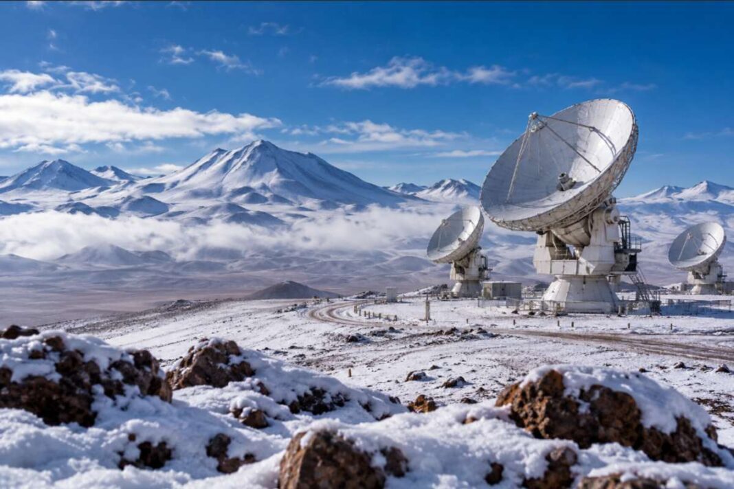

Back-to-back winter storms brought rare, widespread snow and unusually heavy rain to northern Chile’s Atacama Desert in August 2026, temporarily disrupting some of the world’s most important astronomical observatories.
One of the driest places on Earth underwent a striking transformation in August 2026 as a series of winter storms brought widespread snow and unusually heavy rainfall to northern Chile’s Atacama Desert.
Satellite images released by NASA Earth Observatory showed snow spreading across parts of the desert, including the high-altitude Chajnantor Plateau. Later in the month, another storm pushed snow even farther west from the Andes, across the hyper-arid interior and toward Chile’s Pacific coast.
The severe weather also affected astronomical facilities that rely on the Atacama’s exceptionally dry atmosphere and clear skies. The Atacama Large Millimeter/submillimeter Array (ALMA) suspended observations as snow and strong winds reached its high-altitude site.
While snowfall in the Atacama is not unprecedented, the geographical extent of the August 2026 event made it particularly unusual.
Rare Snow Transforms the Atacama Desert
The Atacama Desert stretches across northern Chile and is widely recognized as one of the driest environments on the planet. Some parts of its hyper-arid core receive extremely little precipitation, making significant rain or snowfall especially noteworthy.
NASA’s Landsat 8 and Landsat 9 satellites documented the transformation during August.
Images captured on August 6 and August 14 showed parts of the Chajnantor Plateau changing from the desert’s characteristic brown landscape to snow-covered terrain.
A second weather system later in the month produced even more extensive snowfall. NASA’s Terra satellite captured an image on August 19 showing snow extending westward from the Andes, across parts of the Atacama and close to the Pacific coast south of Antofagasta.
The event was unusual, but it should not be described as the first snowfall in the desert’s recorded history. NASA notes that notable snowfall also occurred in the Atacama in 2025 and 2011.
What distinguished the August 2026 event was how widely the snow spread across a region known for extreme aridity.
ALMA Observatory Suspends Operations
The unusual weather had consequences beyond creating a dramatic desert landscape.
The Atacama is home to several of the world’s most important astronomical facilities because its combination of high altitude, extremely low humidity and generally clear skies provides exceptional conditions for observing the universe.
Among them is the Atacama Large Millimeter/submillimeter Array, better known as ALMA.
Located on the Chajnantor Plateau at an elevation of around 5,000 metres, ALMA uses 66 high-precision antennas to observe millimetre and submillimetre wavelengths of light.
As snow and strong winds reached the plateau in August, ALMA suspended scientific observations and moved its antennas into a protective “survival mode,” according to NASA.
The procedure is designed to protect the sensitive equipment when environmental conditions make normal operations unsafe.
Other astronomical facilities in northern Chile have also dealt with unusual winter conditions during 2026.
The European Southern Observatory reported weather-related precautions at its facilities, while images from Cerro Armazones, the site where ESO’s Extremely Large Telescope is being constructed, showed the normally dry landscape covered in snow.
Atacama Rainfall Reaches Exceptional Levels
The storms did not bring only snow.
At lower elevations, where temperatures were warmer, precipitation fell as rain.
One of the most striking rainfall measurements came from Taltal, a coastal town in northern Chile.
According to NASA, Taltal received nearly 40 millimetres, or 1.6 inches, of rain in three days.
Atmospheric scientist René Garreaud of the University of Chile told NASA that the amount was approximately 10 times the town’s average annual rainfall.
In a region accustomed to extremely limited precipitation, concentrated rainfall can have significant consequences.
Heavy rain affected parts of northern Chile with flooding and mudflows reported in the region. Chilean authorities had already identified flash flooding, mudflows, swollen waterways and disruption to mountain roads among the major winter hazards requiring monitoring and emergency preparation during 2026.
What Caused the Atacama Desert Snow?
The unusual snowfall has a meteorological explanation.
Northern Chile can occasionally receive winter precipitation when particular atmospheric systems move into the region.
One important mechanism involves cutoff lows, areas of low atmospheric pressure that become separated from the main jet-stream circulation and can transport moisture into normally dry regions.
According to NASA, the late-August storm developed from a cutoff low associated with an unusually large atmospheric trough extending from southern South America toward subtropical latitudes.
The system interacted with substantial moisture near Chile’s Pacific coast.
That combination allowed precipitation to spread across an unusually broad area, from offshore waters and coastal regions through the Atacama’s hyper-arid interior and into the Andes.
The result was the extensive snow cover captured by satellites.
Is Climate Change Behind the Atacama Snow?
The unusual nature of the event inevitably raises questions about whether climate change played a role.
However, an individual extreme weather event cannot automatically be attributed to global warming without dedicated scientific analysis.
Current evidence provides a clearer explanation for the immediate meteorological conditions behind the August storms: a large atmospheric trough, a cutoff low and significant coastal moisture.
NASA also discussed the event against the background of developing El Niño conditions, another factor capable of influencing weather patterns in the region.
Climate change can influence the frequency, intensity and distribution of extreme precipitation in different regions, but establishing its contribution to a specific event generally requires attribution research.
For that reason, the August 2026 snowfall is more accurately described as a rare and unusually widespread weather event rather than direct evidence that the Atacama’s long-term climate has fundamentally changed.
Future research may provide a clearer picture of whether events of this type are becoming more frequent or intense.
Why the Atacama Is So Important for Astronomy
The same environmental characteristics that make unusual precipitation noteworthy have also transformed northern Chile into a global centre for astronomy.
The Atacama’s high altitude, dry atmosphere, low humidity and large number of clear nights provide scientists with exceptional observing conditions.
ALMA is among the best-known facilities operating there, but the region hosts several other major astronomical projects.
ESO’s Extremely Large Telescope (ELT) is being constructed at Cerro Armazones. The organization says the location’s clear skies, dry conditions and atmospheric stability were among the reasons the site was selected.
This makes images of snow-covered astronomical facilities particularly striking.
Infrastructure specifically positioned in one of Earth’s driest environments temporarily found itself surrounded by a winter landscape.
What the August 2026 Atacama Storm Revealed
The August storms did not suddenly transform the Atacama Desert into a wet environment, nor do they by themselves establish that the region’s underlying climate has permanently changed.
They did, however, produce an exceptional meteorological episode.
Satellite observations documented widespread snow extending from the Andes across portions of the hyper-arid desert and toward the Pacific coast. Some lower-elevation areas experienced unusually heavy rainfall, while major astronomical facilities temporarily adjusted or suspended operations in response to the severe conditions.
For scientists, the event provides another opportunity to examine how unusual atmospheric systems interact with one of the planet’s most extreme environments.
It also highlights the challenges faced by infrastructure and scientific facilities operating in places where certain forms of severe weather may be rare, but are not impossible.
Sources
This article was prepared using information from official scientific institutions and Chilean government sources:
- NASA Earth Observatory — “Rare, Widespread Snow in the Atacama Desert” (August 27, 2026): Satellite observations and scientific analysis of the August 2026 snowfall, including conditions at ALMA, rainfall in Taltal and the atmospheric systems behind the event.
Read the NASA Earth Observatory report - European Southern Observatory (ESO) — “A Rare Snowy Day for the World’s Biggest Eye on the Sky”: Documentation of rare snowfall at Cerro Armazones, home of ESO’s Extremely Large Telescope, on August 19, 2026.
View the ESO report and imagery - Chile Ministry of Public Works (MOP), Atacama — Winter Plan 2026: Official information on regional preparations for winter hazards, including mudflows, rising waterways, mountain-route disruptions and emergency monitoring.
Read the official MOP Atacama update
Editorial note: Weather events can evolve as new observations and scientific assessments become available. The Prime Brief has distinguished confirmed observations from broader climate attribution and will update this report if significant new evidence emerges.